Newcastle City Council
Tree preservation zone
There is a problem
- 1000 entries with tree-preservation-order field must match the reference field in the tree preservation order dataset
High Gosforth Park
- reference
- 1995/017.W9
- name
- High Gosforth Park
- tree-preservation-order
- 1995/017
- tree-preservation-zone-type
- woodland
- geometry
- MULTIPOLYGON (((-1.619725 55.037106,-1.619744 55.037131,-1.619718 55.037134,-1.619496 55.037172,-1.619493 55.037177,-1.619455 55.037099,-1.619336 55.037057,-1.619311 55.036999,-1.619292 55.036984,-1.619276 55.036980,-1.619257 55.036979,-1.619234 55.036981,-1.619213 55.036988,-1.619191 55.036998,-1.619179 55.037008,-1.618832 55.037132,-1.618754 55.037156,-1.618723 55.037163,-1.618674 55.037172,-1.618617 55.037180,-1.617971 55.037251,-1.617348 55.037242,-1.617166 55.037223,-1.616993 55.037220,-1.616597 55.037208,-1.616457 55.037202,-1.616405 55.037407,-1.616592 55.037426,-1.616629 55.037428,-1.617014 55.037434,-1.617273 55.037433,-1.617458 55.037428,-1.617765 55.037425,-1.618179 55.037401,-1.618263 55.037402,-1.618566 55.037388,-1.618689 55.037385,-1.619073 55.037351,-1.619020 55.037549,-1.619018 55.037644,-1.619005 55.037713,-1.618975 55.037846,-1.618953 55.037972,-1.620125 55.038081,-1.620607 55.038123,-1.620609 55.038121,-1.622054 55.038267,-1.622029 55.038376,-1.622075 55.038379,-1.622062 55.038430,-1.622016 55.038426,-1.622006 55.038473,-1.621951 55.038694,-1.622052 55.038709,-1.621920 55.039226,-1.621951 55.039217,-1.622033 55.039186,-1.622125 55.039142,-1.622189 55.039109,-1.622247 55.039067,-1.622326 55.038999,-1.622400 55.038916,-1.622443 55.038856,-1.622504 55.038759,-1.622549 55.038670,-1.622635 55.038493,-1.622806 55.038502,-1.622862 55.038296,-1.622907 55.038116,-1.622837 55.038044,-1.622468 55.038011,-1.622423 55.037993,-1.622364 55.037982,-1.622302 55.037977,-1.622282 55.037886,-1.622272 55.037855,-1.622223 55.037823,-1.622143 55.037797,-1.622085 55.037784,-1.621866 55.037756,-1.621671 55.037739,-1.621557 55.037727,-1.621348 55.037711,-1.621035 55.037683,-1.620968 55.037675,-1.620756 55.037635,-1.620612 55.037614,-1.620612 55.037552,-1.620743 55.037017,-1.621340 55.037092,-1.621358 55.037044,-1.621561 55.037068,-1.621563 55.037062,-1.621741 55.037082,-1.621740 55.037089,-1.621883 55.037108,-1.621867 55.037154,-1.621949 55.037162,-1.622422 55.037216,-1.622426 55.037210,-1.622492 55.037225,-1.622522 55.037169,-1.622534 55.037150,-1.622568 55.037083,-1.623149 55.037092,-1.623182 55.036925,-1.623239 55.036658,-1.623254 55.036506,-1.623282 55.036305,-1.623305 55.036095,-1.623301 55.036068,-1.623293 55.036055,-1.623276 55.036034,-1.623244 55.036007,-1.623104 55.035906,-1.623101 55.035883,-1.622245 55.036253,-1.622070 55.036294,-1.621933 55.036353,-1.621579 55.036496,-1.621409 55.036562,-1.621217 55.036640,-1.621073 55.036704,-1.620954 55.036751,-1.620697 55.036844,-1.620555 55.036891,-1.619996 55.037045,-1.619881 55.037072,-1.619725 55.037106)))
- point
- POINT (-1.621012 55.037387)
- notes
- These data are update live via a feed to NCC's Tree Managament System, EzyTreev
- entry-date
- 2022-07-01
- start-date
- 1995-01-01
- end-date
How to fix this issue
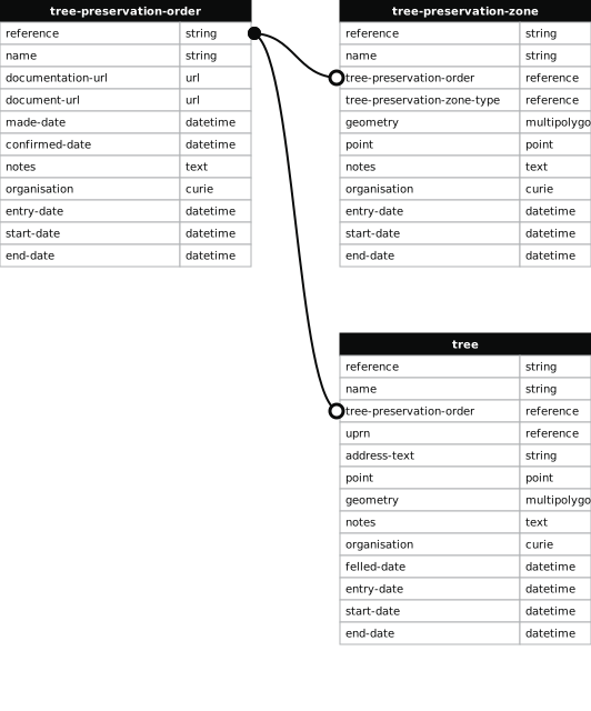
Your data is missing a tree-preservation-order.
The Tree preservation zone guidance explains how to fix the issue:
tree-preservation-order
The reference for the tree preservation order that covers this zone.
How to improve Newcastle City Council’s data
- Fix the errors indicated
- Use the check service to make sure the data meets the standard
- Publish the updated data on the endpoint URL